
Category:Washington State Route 410
Highway in Washington  | |||||
| Upload media | |||||
| Instance of | |||||
|---|---|---|---|---|---|
| Located in protected area | |||||
| Location | Washington, Pacific Northwest, Western North America, North America, Northern Hemisphere | ||||
| Transport network | |||||
| Owned by | |||||
| Maintained by | |||||
| Inception |
| ||||
| Length |
| ||||
| |||||
| « First · 397 · 401 · 403 · 407 · 409 · 410 · 411 · 431 · Last » |
| I-5 · I-82 · I-90 · I-182 · I-205 · I-405 · I-605 · I-705 |
| US-2 · US-10 · US-12 · US-95 · US-97 · US-99 · US-101 · US-195 · US-197 · US-295 · US-395 · US-730 · US-830 |
English: This category should contain files related to Washington State Route 410.
Subcategories
This category has the following 12 subcategories, out of 12 total.
Media in category "Washington State Route 410"
The following 38 files are in this category, out of 38 total.
-
 WA-410.svg 600 × 600; 6 KB
-
 Clearwater Lodge on Greenwater River 01.jpg 4,288 × 2,848; 6.41 MB
-
 Downstream on Greenwater River from WA SR 410 - 01.jpg 4,288 × 2,848; 6.31 MB
-
 Entering King County on WA SR 410 - 01.jpg 4,288 × 2,848; 6.17 MB
-
 Entering Pierce County on WA SR 410 - 01.jpg 2,848 × 4,288; 6 MB
-
 Entering Pierce County on WA SR 410 - 02.jpg 4,288 × 2,848; 6.46 MB
-
 Entering Pierce County on WA SR 410 - 03.jpg 4,288 × 2,848; 6.31 MB
-
 Greenwater, WA — Naches Tavern.jpg 4,752 × 3,168; 16.21 MB
-
.jpg/120px-Heading_up_east_side_of_Chinook_Pass_(1457102948).jpg) Heading up east side of Chinook Pass (1457102948).jpg 1,024 × 768; 686 KB
Heading up east side of Chinook Pass (1457102948).jpg 1,024 × 768; 686 KB
-
.jpg/120px-Highway_410_and_White_River._101967._slide_(544ed736225a4da6a2e6fbc887013c32).jpg) Highway 410 and White River. 101967. slide (544ed736225a4da6a2e6fbc887013c32).jpg 2,140 × 1,457; 912 KB
Highway 410 and White River. 101967. slide (544ed736225a4da6a2e6fbc887013c32).jpg 2,140 × 1,457; 912 KB
-
.jpg/120px-Highway_410_plowed_clean_of_snow._Tall_snowbanks._Mt_Rainier._61984._slide_(88b8346a26224b23a37635261b8b4d81).jpg)
-
.jpg/120px-Highway_410_plowed_free_of_snow._Tall_snowbanks._Mt_Rainier._61984._slide_(6a37b132692248bba7258e59e9f21baf).jpg)
-
.jpg/120px-Highway_410_with_high_snowbanks_and_car._61984._slide_(96caff1f5a0b45408076bb440bf83f42).jpg)
-
.jpg/120px-Highway_410_with_snow_plowed_off._Tall_snowbanks._Mt_Rainier._61984._slide_(b78d1ad1cef74396b75eaa428abf4c58).jpg)
-
.jpg/120px-Hwy_123_Sign_Install_5_(6973380720).jpg) Hwy 123 Sign Install 5 (6973380720).jpg 3,072 × 2,304; 1.4 MB
Hwy 123 Sign Install 5 (6973380720).jpg 3,072 × 2,304; 1.4 MB
-
-
 Moss on Greenwater River bridge, WA SR 410.jpg 4,288 × 2,848; 6.86 MB
-
 Mount Rainier 2023-06-30 03.jpg 6,000 × 4,000; 4.58 MB
-
.jpg/120px-Mt._Rainier_(5559658987).jpg) Mt. Rainier (5559658987).jpg 1,000 × 750; 276 KB
Mt. Rainier (5559658987).jpg 1,000 × 750; 276 KB
-
 Naches Peak from Highway 410 switchbacks.jpg 2,264 × 1,525; 1.07 MB
-
 Peak of Mount Rainier from Washington SR 410 just south of the road to Sunrise 01.jpg 6,000 × 4,000; 8.34 MB
-
 Peak of Mount Rainier from Washington SR 410 just south of the road to Sunrise 02.jpg 6,000 × 4,000; 8.3 MB
-
 Peak of Mount Rainier from Washington SR 410 just south of the road to Sunrise 03.jpg 6,000 × 4,000; 8.5 MB
-
 Peak of Mount Rainier from Washington SR 410 just south of the road to Sunrise 04.jpg 6,000 × 4,000; 9.82 MB
-

-
 SR 123 area history.svg 1,152 × 640; 29 KB
-
.jpg/120px-Starting_up_road_on_east_side_of_Chinook_Pass%2C_dry_climate_from_rainshadow_of_Cascade_Mountains_(3935892005).jpg)
-
 Upstream on Greenwater River from WA SR 410 - 01.jpg 4,288 × 2,848; 6.35 MB
-
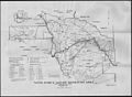
 US 410 Sumner freeway topo.png 1,000 × 800; 1.67 MB
-

-
 WA 410 952.jpg 2,592 × 4,608; 2.54 MB
-
 WA 410 955.jpg 4,608 × 2,592; 2.77 MB
-
 Washington State Route 410.svg 1,152 × 640; 168 KB
-
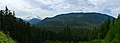
 WashingtonSR410.jpg 2,339 × 1,167; 897 KB
-
.jpg/120px-Weyerhauser_Mainline_Road_Enumclaw_Washington_Bridge_(20166044811).jpg) Weyerhauser Mainline Road Enumclaw Washington Bridge (20166044811).jpg 5,617 × 3,399; 19.79 MB
Weyerhauser Mainline Road Enumclaw Washington Bridge (20166044811).jpg 5,617 × 3,399; 19.79 MB
-
-

-
 White River from Washington SR 410 just south of the road to Sunrise.jpg 6,000 × 4,000; 11.71 MB


.jpg)
.jpg)
.jpg)
.jpg)
.jpg)
.jpg)
.jpg)


.jpg)


.jpg)


.jpg)

